Publications /
Policy Brief
This paper was originally published as a chapter in the ISPI report The Pursuit of Smart Mobility in Urban Nodes: Trends and Innovation for Citizens and Freight.
Agglomeration economies have historically supported industrialisation and global integration by concentrating firms, labour and infrastructure in dynamic urban cores. However, these same forces have also generated persistent patterns of territorial polarisation. Drawing on New Economic Geography, this chapter interprets spatial development through the interaction of centripetal forces, which drive concentration, and centrifugal forces, which promote dispersion. In many cases, the former dominates, giving rise to a self-reinforcing spatial configuration in which economic activity remains geographically concentrated.
Within this framework, the chapter introduces the concept of a “polarisation trap”, whereby economic gains generated across regions are systematically reabsorbed by the core through trade, investment and labour linkages. As a result, improvements in connectivity – particularly through transport infrastructure and emerging smart mobility systems – do not necessarily foster convergence, but may instead reinforce existing hierarchies by disproportionately benefiting already well-integrated regions. The Moroccan case illustrates these dynamics clearly. The country’s economic geography is characterised by a marked spatial asymmetry: a highly dynamic and globally integrated coastal corridor coexists with a comparatively underproductive hinterland. This imbalance is structural. Half of Morocco’s twelve regions account for more than 80% of the national Gross Domestic Product (GDP), reflecting a strong concentration of economic activity within a limited territorial core. At the centre of this system is the Casablanca-Settat region, which alone generates around 32.2% of national wealth and functions as the country’s primary industrial, financial and logistical hub.1
While this concentration has played a key role in accelerating industrialisation and global integration, it raises questions about the sustainability of the current spatial model. Beyond its contribution to growth, spatial polarisation is associated with persistent regional disparities in income, productivity and access to opportunities. This reflects a broader tension in spatial economics: the forces that enhance efficiency through agglomeration may simultaneously produce durable territorial inequalities.
This chapter examines whether Morocco’s spatial configuration represents an optimal development trajectory or a suboptimal equilibrium characterised by self-reinforcing polarisation. In particular, it assesses whether the concentration of economic activity around Casablanca continues to act as a national growth engine or has become a structural constraint on convergence and inclusive regional development.
To address this question, the analysis adopts a spatial economics perspective, focusing on agglomeration dynamics, interregional linkages and unequal market access. Special attention is given to Casablanca as a primate city, whose dominance reflects both historical advantages and ongoing processes of cumulative causation.
Finally, the chapter considers Morocco’s efforts to transition towards a more centrifugal development model – including advanced regionalisation reforms, large-scale infrastructure investments and targeted territorial policies. While these initiatives signal a strategic shift towards rebalancing spatial development, their effectiveness remains conditioned by the structural dynamics underpinning the existing core–periphery system.
Theoretical Foundations: Spatial Economics and Agglomeration
The field of spatial economics is concerned with why economic activity clusters in specific geographic locations rather than spreading evenly across space. The literature identifies two primary drivers: “first-nature geography” and “second-nature geography”.
“First-nature geography” refers to exogenous physical advantages, such as access to deep-water ports, fertile soil or proximity to international markets. Casablanca’s rise was cemented by its Atlantic coastline, which transformed it into a gateway for Euro-African trade. However, modern spatial economics suggests that “second-nature geography” – the endogenous decisions of firms and workers to co-locate – is the more powerful force today. This clustering creates “agglomeration economies”, in which productivity increases due to shared infrastructure, labour-market pooling and knowledge spillovers.2
These forces are inherently centripetal; they pull capital, talent and resources toward the centre. Conversely, “centrifugal forces” (or dispersion forces), such as high land rents, traffic congestion and pollution, eventually push activity away from the core.3 In the Moroccan context, the centripetal forces of the Casablanca region have historically overwhelmed any centrifugal push, leading to a “Primate City” share of national output.
Spatial Concentration and Regional Polarisation in Morocco
Building on the theoretical foundations of spatial economics, the Moroccan case illustrates how agglomeration forces translate into concrete territorial structures. While centripetal dynamics explain the concentration of economic activity, their long- term manifestation often results in deeply entrenched spatial inequalities shaped by historical, institutional and structural factors. In Morocco, these dynamics have produced a highly polarised economic geography dominated by a limited number of interconnected urban regions.
Since independence, Morocco’s development trajectory has been largely influenced by a centralised planning model, in which economic activity, infrastructure and decision-making power were concentrated in key urban centres. Although recent reforms have introduced elements of decentralisation and advanced regionalisation, the spatial imprint of earlier policies remains strong, contributing to persistent territorial imbalances. More broadly, regional disparities in Morocco stem from a complex interplay among geographic constraints, historical development patterns, global economic integration and public policy choices, all of which have reinforced the concentration of wealth creation in specific areas.
At the core of this spatial structure lies a pronounced core- periphery configuration, consistent with the predictions of spatial economic theory.4 In Morocco, economic activity is heavily concentrated along a narrow coastal corridor stretching from Casablanca to Tangier, often referred to as the country’s industrial backbone. This area alone accounts for a disproportionate share of manufacturing employment – over half of total industrial jobs – highlighting the intensity of spatial concentration.5 The hinterland, by contrast, is characterised by fragmented and isolated production systems, with smaller urban clusters that remain weakly integrated into national and global value chains.
This configuration extends beyond sectoral concentration to define the broader territorial organisation of the Moroccan economy. A contiguous group of six regions – Tanger-Tétouan- Al Hoceima, Fès-Meknès, Rabat-Salé-Kénitra, Béni Mellal- Khénifra, Casablanca-Settat and Marrakech-Safi – forms what can be described as the country’s economic core, collectively generating more than 80% of national GDP. Given the fish- shaped-like cartographical representation of this cluster’s territorial limits (Figure 9.1), we refer to this set of regions as the Moroccan “fish”. This spatial cluster concentrates not only production but also infrastructure, market access and human capital, reinforcing its cumulative advantage over peripheral regions.
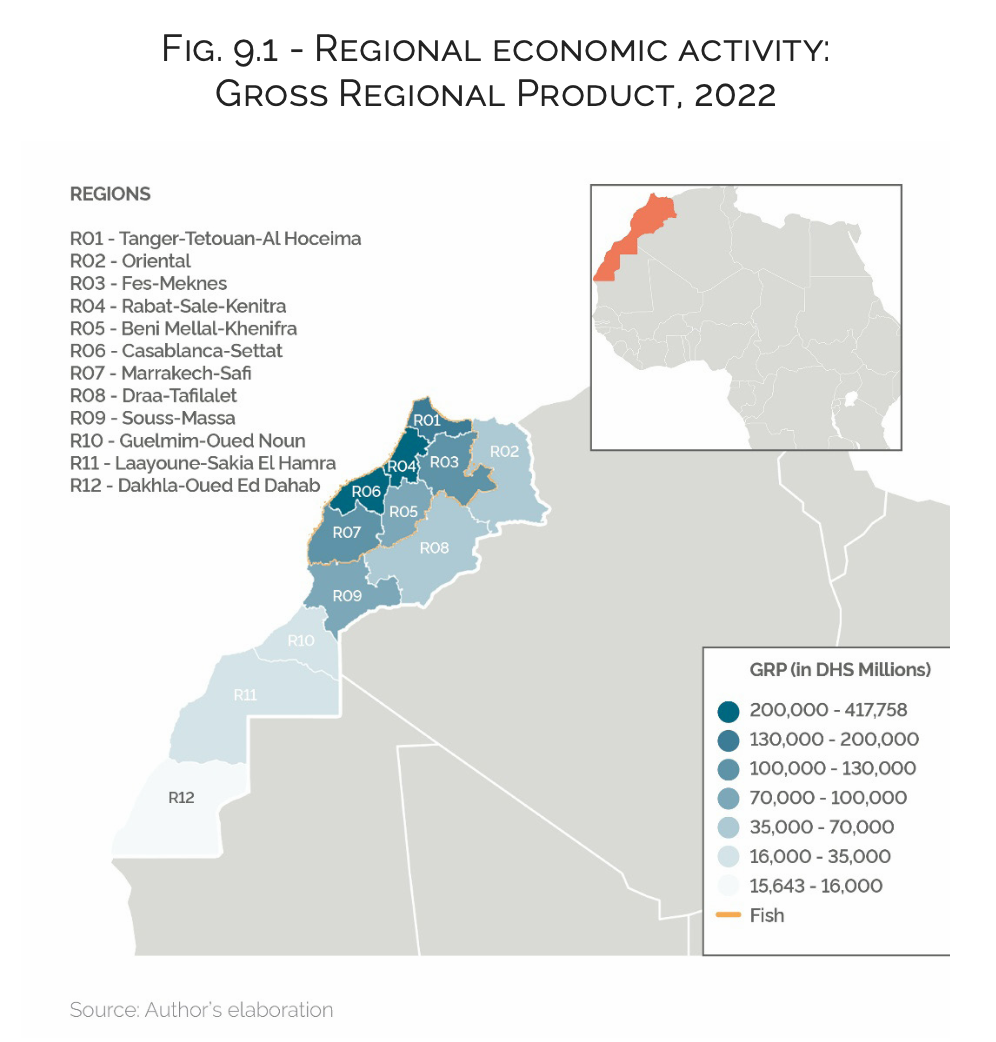
Within this system, the Casablanca region occupies a dominant position as the primary economic hub. Accounting for over 32% of national output and exhibiting significantly higher productivity levels than the national average, the region exemplifies the powerful effects of agglomeration economies.6 At a finer spatial scale, disparities become even more pronounced: productivity per worker in major urban provinces is estimated to be up to 62% higher than in other areas, reflecting strong intra-regional inequalities.7 These patterns confirm that agglomeration benefits are not evenly distributed, even within the most developed regions.
However, the Moroccan case also highlights a critical limitation of agglomeration-driven growth: its tendency to generate self- reinforcing polarisation through interregional linkages. Input- output analyses of Moroccan economy reveal a high degree of structural interdependence between regions, with Casablanca- Settat acting as the primary internal trade partner for most of the country.8 This centrality implies that economic shocks, investments or demand increases originating in peripheral regions often propagate through production and income linkages toward the core. As a result, a significant share of the economic benefits generated outside the core is effectively reabsorbed by it.
This mechanism can be understood as a form of spatial feedback effect, in which hierarchical interregional relationships amplify existing inequalities. Consequently, the Moroccan economic system exhibits strong inertia, meaning that the structure of linkages itself helps maintain spatial concentration over time. In practical terms, this suggests that new investments in lagging regions may have limited local multiplier effects, as part of the induced demand leaks toward more integrated and diversified regions – primarily Casablanca and other major urban centres.
Consequently, the Moroccan spatial economy can be interpreted as exhibiting characteristics of a self-reinforcing polarisation process, where centripetal forces are continuously strengthened by the structure of interregional interactions. This dynamic aligns with broader findings in the literature, which emphasise that market mechanisms alone rarely lead to a more balanced spatial distribution of economic activity.9 Instead, without targeted policy interventions, agglomeration economies tend to exacerbate regional disparities, particularly in developing and emerging economies.
The implications of this spatial configuration are significant. While the concentration of economic activity has supported Morocco’s integration into global markets – leveraging the strategic location of coastal regions and their connectivity to Europe – it has also contributed to persistent inequalities in income, access to services and development outcomes across regions. Peripheral and rural areas remain disproportionately affected by poverty and limited economic opportunities, with multidimensional poverty still overwhelmingly concentrated outside urban cores.10
In sum, the Moroccan case illustrates the dual nature of agglomeration processes introduced in the previous section. The same centripetal forces that have driven structural transformation and economic growth have also produced a highly uneven territorial structure, characterised by strong core–periphery divides and limited diffusion of development benefits. This configuration provides a crucial foundation for understanding the persistence of regional inequalities and sets the stage for analysing the mechanisms through which spatial concentration may evolve into a structural constraint on inclusive growth.
Economic Growth and Regional Inequality
While spatial economics explains why economic activity concentrates, it also reveals a fundamental tension: the same agglomeration forces that drive growth can simultaneously generate persistent territorial inequalities. Across both developed and developing economies, growth rarely unfolds evenly. Instead, it tends to cluster in regions that already possess structural advantages – favourable geographical positions, natural endowments, dense infrastructure, skilled labour pools and strong market access.
This uneven geography of development is not incidental but systemic. Agglomeration economies – considered as powerful centripetal forces – reinforce themselves over time, attracting firms and workers into a cumulative process of spatial concentration. In the absence of effective countervailing mechanisms, these dynamics can produce what are often described as “two-speed economies”, where leading metropolitan regions accelerate while peripheral territories lag behind.
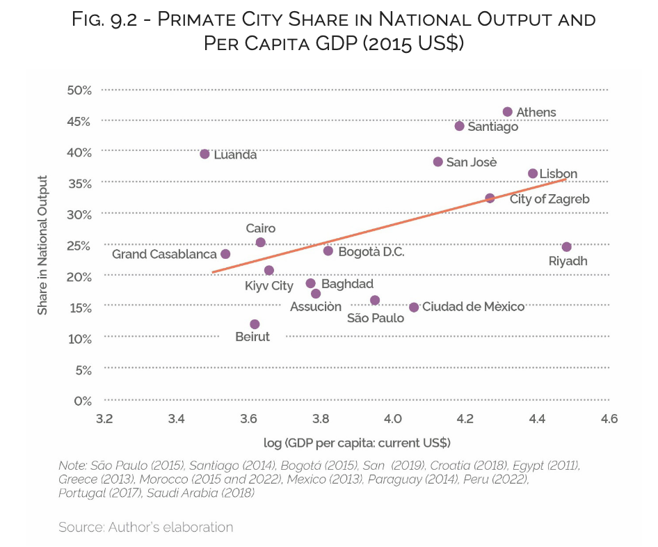
International experience illustrates this pattern clearly. Major cities such as Santiago, Athens or Lisbon have emerged as dominant economic hubs, concentrating a disproportionate share of national output, while rural and internal regions struggle to integrate into growth processes. However, this divergence appears to be less pronounced in developing countries, where cities such as São Paulo, Bogotá or Cairo represent relatively smaller shares of national output than those observed in developed countries (Figure 9.2).
Morocco reflects these global dynamics in a particularly acute form. The economic weight of Casablanca city – which represents roughly one quarter of Morocco’s GDP – places the country slightly above the typical level of spatial concentration observed in economies at similar income per capita levels. Its primacy is closer to that of strongly monocentric systems such as Cairo or Bogotá but remains less than that of capitals like Athens or Santiago, where a single metropolitan area dominates the national economic life, representing roughly half of the country’s wealth creation. Although this concentration has supported industrialisation and global integration, it has also reinforced structural divides between dynamic coastal cores and less connected hinterland regions.
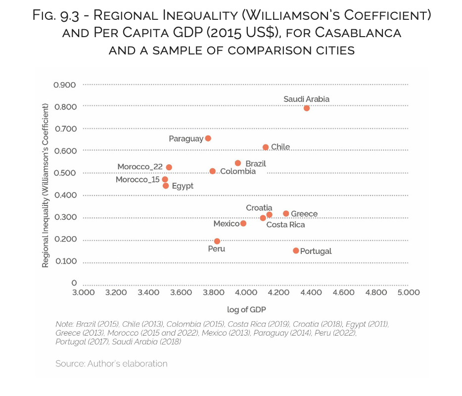
Empirical evidence suggests that these disparities are not naturally correcting over time. Recent trends in Morocco point to renewed regional divergence since 2015, with inequality levels remaining high by international standards – consistent with the upward phase of Williamson’s inverted-U shaped curve, where growth increases spatial disparities. Although the hypothesis predicts eventual convergence through improved connectivity, Morocco’s experience suggests this transition may be delayed or incomplete despite significant infrastructure gains.
Overall, growth has a dual effect: it drives national prosperity but also risks deepening territorial divides. Without targeted, place-based policies, agglomeration forces may entrench inequalities and weaken long-term cohesion.
Casablanca-Centric Market Access and Spatial Inequality As seen in the previous section, regional inequality in Morocco is relatively high by international standards, and it is fundamentally structured around the dominance of the Casablanca metropolitan region. As the country’s primary industrial and logistics hub, Casablanca-Settat concentrates a disproportionate share of manufacturing activity, infrastructure and connectivity. This spatial configuration translates into a stark asymmetry in market access: firms located within and around Casablanca benefit from dense transport networks, proximity to major ports and strong integration into both domestic and international trade flows, while more remote regions face significantly higher costs of economic interaction.
Empirical evidence from the Spatial Computable General Equilibrium (SCGE)11 confirms the Casablanca-centric pattern. Provinces in the Casablanca-Settat region show consistent gains in GRP following reductions in transport costs, with strong performance in peri-urban areas such as Berrechid, Médiouna and Nouaceur. Improved connectivity thus disproportionately benefits regions already integrated into the national core.
This reflects a standard New Economic Geography mechanism: lower transport costs strengthen agglomeration forces where advantages already exist. In Casablanca, better accessibility reduces input costs, expands market size and reinforces production linkages. At the same time, growth diffuses within the broader metropolitan area, allowing nearby provinces to attract investment due to lower land costs while remaining connected to the core.
By contrast, more remote regions experience limited or even negative long-run effects. Weaker integration into production networks and higher effective transport costs constrain their ability to benefit from improved infrastructure. As a result, they capture fewer gains from increased connectivity.
Spatial Rebalancing and Smart Mobility
Escaping the polarisation trap requires a structural transformation of Morocco’s spatial development model. The current centripetal configuration – centred on Casablanca – has concentrated economic activity within a limited core. Moving towards a more centrifugal model implies redistributing not only infrastructure and capital, but also the mechanisms of value creation, allowing local economies to retain a greater share of economic gains.12
This transition is institutionally supported by the Advanced Regionalisation reform, which strengthens regional autonomy and enables more territorially differentiated development strategies.
Within this framework, transport infrastructure – and more broadly, smart mobility – plays a central role. By improving connectivity, it can reduce unequal market access and facilitate the integration of peripheral regions into national and global value chains. However, its effects are not neutral: depending on design and geography, it may either reinforce existing cores or promote spatial diffusion.
Recent infrastructure projects illustrate this dual dynamic. The Tiznit-Dakhla expressway improves connectivity across southern regions, generating large increases in market access and regional output, particularly in highly peripheral areas such as Dakhla-Oued Ed-Dahab.13 Similarly, the Marrakech- Fès highway enhances inland connectivity across the Atlas, strengthening the economic position of provinces such as Khénifra and El Hajeb and fostering their emergence as new productive nodes within the national economy.14
Simulation results further indicate that these accessibility gains translate into disproportionately higher economic benefits for inland and peripheral provinces directly connected to the corridor, while also generating broader network effects across adjacent regions.15 However, these centrifugal effects remain partial: gains depend on local absorptive capacity and overall reductions in regional disparities are limited.
To address these constraints, policy has increasingly combined infrastructure with broader development strategies, including the creation of new growth poles (e.g. Dakhla Atlantic Port, Noor Ouarzazate) and targeted investment incentives introduced in 2022. This reflects a shift towards a multi-polar development model, where regions develop complementary economic roles within an integrated national system.
Conclusion
The relationship between infrastructure, smart mobility and spatial distribution is inherently ambivalent. Improvements in connectivity can either reduce or reinforce regional disparities, depending on pre-existing economic structures and institutional conditions.
Although enhanced mobility lowers transport costs and expands market access, it does not automatically lead to convergence. Regions with stronger productive bases, higher institutional quality, and deeper integration into economic networks are better positioned to capture these gains. Consequently, infrastructure investment alone is often insufficient to offset entrenched spatial inequalities.
Achieving territorial rebalancing, therefore requires a broader policy mix, including place-based interventions that strengthen local productive capacity, support industrial ecosystems and enhance institutional effectiveness in lagging regions. Without such complementary measures, centripetal forces are likely to persist, even alongside substantial improvements in connectivity.
Ultimately, spatial development reflects not only the configuration of transport networks but also the uneven distribution of regional capabilities. More balanced growth depends on aligning mobility improvements with wider economic and institutional transformation, an issue clearly illustrated by the persistence of core-periphery dynamics in the Moroccan case.
_________________________________________________________________________________
1 HCP (Haut Commissariat au Plan), Comptes régionaux, Rabat, 2023.
2 S.J. Redding, “Spatial economics”, in Oxford Research Encyclopedia of Economics and Finance, Princeton University, NBER, and CEPR, 2024.
3 M. Fujita, P. Krugman, and A.J. Venables, The spatial economy: Cities, regions and international trade, MIT Press, 1999.
4 P. Krugman, “Increasing returns and economic geography”, Journal of Political Economy, vol. 99, 1991, pp.483-99.
5 HCP (Haut Commissariat au Plan), Comptes régionaux, Rabat, 2023.
6 Ibid.
7 E.A. Haddad and M. Arbouch, “Regional economic development in Morocco”, in K. El Aynaoui and A. Oqubay (eds.), The Oxford Handbook of the Moroccan Economy Regional Economic Development in Morocco, Oxford University Press, 2026.
8 Ibid.
9 L.B.M. Mennes, J. Tinbergen, and J.G. Waardenburg, The element of space in development planning, 1969; D. Neumark and H. Simpson, “Place-based policies”, in G. Duranton, J.V. Henderson, and W.C. Strange (eds.), Handbook of regional and urban economics, 2015.
10 Haddad and Harbouch (2026).
11 M. Arbouch and E.A. Haddad, “Disentangling regional economic and environmental impacts of transportation costs in orocco: An inter-province CGE approach”, Economic Systems Research, 2026.
12 R. Goulding, A. Leaver, J. Silver, Centripetal cities: A critique of supply-side urban development, The University of Sheffield, 2024.
13 E.A. Haddad, M. Arbouch, A.A. Rocha, and V.A. Vale, Valuing the economic cost of remoteness: A case study of the Tiznit-Dakhla expressway in Morocco (RP-11/22). Policy Center for the New South, 2022.
14 M. Arbouch, “Assessing the economic and environmental impacts of improved accessibility: A spatial CGE approach to the Marrakech–Fès highway project in Morocco”, Regional Science Policy & Practice, vol. 18, no. 100277, 2026.
15 Ibid.