Publications /
Policy Brief
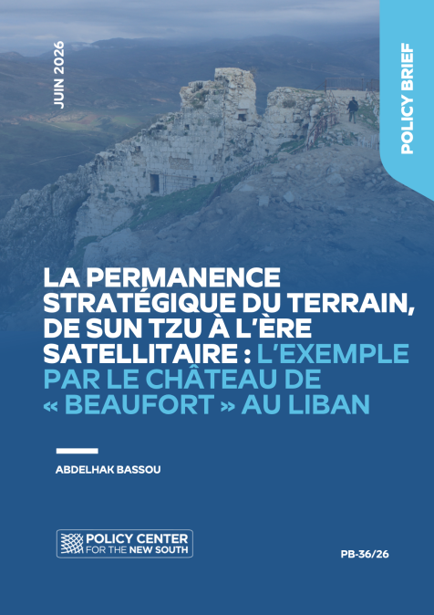
At the end of May 2026, Israeli airstrikes targeted the surroundings of Beaufort Castle (Qalaat al-Chaqif), near Nabatiyeh, before the Israeli army announced that it had captured the site. This development raises a fundamental question: why does a medieval fortified hilltop retain military value in the age of satellites, drones, and cruise missiles?
This Policy Brief argues that Beaufort's significance is geographical before it is ideological or technological. Overlooking the Litani Valley from an elevation of more than 700 meters, the site offers three enduring and classic military advantages: observation of enemy movements, denial of lines of approach, and protection of the occupying force. This strategic logic has remained unchanged from the Crusader period through the Israeli operations of 1982 and the recapture of the site in 2026.
Drawing on the strategic thought of Sun Tzu, Clausewitz, and Jomini, this paper demonstrates that terrain remains a fundamental principle of military strategy. Technology transforms military methods, but it does not eliminate their essential functions: to observe, deny, hold, and control. The war in Ukraine confirms this reality. Battles such as Bakhmut and Avdiivka illustrate that the capture and control of terrain remain slow and costly, even in the era of highly sophisticated weapons systems.
Paradoxically, growing dependence on electromagnetic systems has restored strategic importance to physical terrain, which increasingly serves as the interface between the physical and electromagnetic domains, between sensors and signal interference. Long-range strikes can destroy targets, but they cannot hold territory. Effective control of space still requires a physical presence on the ground.
Introduction
At the end of May 2026, Beaufort Castle, known locally by its Arabic name Qalaat al-Chaqif, returned to the forefront of military developments in southern Lebanon. Israeli airstrikes targeted the surroundings of this medieval fortress near Nabatiyeh, after which the Israeli army announced that it had seized both the site and the strategic elevation on which it stands. This development immediately gave the location a dual significance that transcends political interpretations concerning the victories or defeats of either party to the conflict. That significance lies both in the site's historical heritage and in its enduring strategic utility.
Beaufort possesses considerable historical value because it forms part of the long history of Levantine fortifications. It also retains military importance because its location continues to provide an operational advantage in a theatre where ground manoeuvre, drones, rockets, artillery, intelligence, and electronic warfare converge.¹
Historical and contemporary accounts of the site's role in warfare raise a broader question: why does a rocky hilltop fortress built in the Middle Ages remain militarily significant in an era of surveillance satellites, reconnaissance and strike drones, cruise missiles, and precision-guided weapons?
This question gives rise to two related considerations:
Does this reflect the enduring nature of the fundamental principles of warfare and the physical constraints imposed by geography, constraints that technology transforms but does not eliminate?
Or must we accept that while technology changes the ways armies observe, strike, coordinate, and protect themselves, it cannot entirely replace the need to occupy, deny, monitor, and hold territory?
Viewed from this perspective, Beaufort is more than a castle or a simple fortification. It is a case study demonstrating that terrain is not a pre-modern relic of military strategy. Rather, it remains both a source of constraint and an opportunity. Relief, valleys, ridgelines, water obstacles, and lines of communication continue to shape military manoeuvre. Even as warfare becomes increasingly satellite-enabled, digitized, and electromagnetic, armed forces must still move through physical space, occupy positions, secure routes, protect rear areas, and monitor enemy movements.
To address these questions and examine the assumptions that underpin them, this Policy Brief first reviews the geographical and military significance of Beaufort beyond historical periods and ideological divisions. It then examines the enduring importance of terrain in military strategy before assessing how technological developments have transformed modern warfare. Finally, it draws broader lessons from the site's remarkable strategic longevity.
I. BEAUFORT: A POSITION WHOSE MILITARY VALUE TRANSCENDS TIME AND PRECEDES IDEOLOGIES
The military significance of Beaufort Fortress has always derived from its geography, regardless of who occupied it, the doctrine they embraced, the historical period, or the military technologies available at the time.
1. A Fortress Born of Geography
By virtue of its topography, Beaufort has endured through successive eras marked by religious, ideological, and military conflict. Perched on a rocky promontory more than 700 meters above sea level, according to contemporary descriptions, the fortress overlooks the Litani Valley and lies close to Nabatiyeh. UNESCO describes Qalaat al-Chaqif as a commanding position that dominates a vast surrounding landscape. Heritage sources likewise identify the site as one of the most significant examples of medieval military architecture in the Levant, particularly because of its association with Crusader fortifications.
Several historical sources suggest that the site existed before the arrival of the Crusaders. Nevertheless, the event most frequently highlighted in historical accounts is its capture in 1139 by Fulk of Anjou, King of Jerusalem. In 1179, Crusader survivors of the Battle of Marj Ayyoun sought refuge within its walls to escape Saladin's forces, which ultimately captured the fortress in 1190. Around 1240, Beaufort returned to Crusader control before being sold to the Knights Templar in 1260. In 1268, it was seized by the Mamluk Sultan Baybars. This succession of rulers demonstrates that the site's strategic value persisted across centuries and transcended political, religious, and military doctrines. Beaufort has always owed its importance to its geography.
That geography provides three timeless military advantages:
First, it offers observation. From elevated ground, one can detect approaching forces, monitor lines of communication, and track enemy movements.
Second, it enables denial. Whoever controls the high ground can threaten valleys, passes, and avenues of approach.
Finally, it provides protection. An attacking force must advance uphill, exposing itself while losing both time and momentum.
Before becoming a symbol, Beaufort was, and remains, a military position.
2. The Twentieth Century: The Enduring Relevance of an Ancient Site in Modern Warfare
Modern warfare did not diminish this strategic logic. During the Lebanese Civil War and throughout the Israeli-Palestinian confrontations, Beaufort retained its military function. The Palestine Liberation Organization (PLO) established positions there during the 1970s. During Israel's Operation Peace for Galilee in June 1982, the fortress and its surroundings were subjected to heavy bombardment before being captured by Israeli forces. The objective was not archaeological preservation but rather control of a commanding elevation overlooking large portions of southern Lebanon and Israel's northern frontier.
The Israeli army subsequently converted the area into a military outpost equipped with infrastructure suited to contemporary warfare. When Israeli forces withdrew from southern Lebanon in May 2000, the military installations near the castle were deliberately destroyed to prevent their future use. The very decision to demolish the base before departing demonstrates that the withdrawing force still recognized the strategic value of the site. Beaufort thus became simultaneously a place of memory, symbolic confrontation, and strategic observation.
In 2026, this same strategic logic reappeared within a far more technologically sophisticated operational environment. Drones, missiles, surveillance systems, and advanced communications networks did not diminish Beaufort's importance. On the contrary, they reintegrated the fortress into a broader combat architecture. Today, a ridgeline is no longer merely a position from which soldiers defend territory; it may also serve as an observation hub, a sensor platform, a communications relay, a protective position, an electronic warfare node, or a command-and-control point.
II. THE STRATEGIC ENDURANCE OF TERRAIN: WHAT TECHNOLOGY CANNOT ELIMINATE
Technology may exploit terrain or alter the way it is used, but it cannot eliminate either its strategic importance or its military functions. The nature of the terrain determines how it is occupied, defended, and preserved. In reality, it is the terrain that dictates which technologies should be employed—not the reverse.
1. Terrain Makes Possible What Technology Alone Cannot
A common misconception lies in failing to distinguish between the ability to strike and the ability to control.
An army can strike targets at great distance without maintaining a lasting presence. It can destroy a position without occupying it. It can observe through satellites without possessing continuous tactical awareness on the ground. Technology expands the spatial reach of warfare, but control remains inseparable from physical presence, ground maneuver, and sustained occupation.
In Beaufort's case, occupying the fortress enables forces to monitor movements around the Litani Valley, influence the north-south routes linking southern Lebanon to the country's interior, cover avenues of approach, observe nearby localities, protect forward-deployed forces, and prevent enemy infiltration.
This is where terrain remains decisive: it enables control.
Technology alone cannot provide this advantage. Regardless of its size, sophistication, orbital persistence, or associated weaponry, a satellite cannot offer the same degree of strategic dominance over southern Lebanon as the physical occupation of Beaufort Castle.
2. From Sun Tzu to Clausewitz: Terrain as a Permanent Strategic Principle
Almost every major military theorist has recognized the decisive importance of terrain, topography, and relief in warfare.
Sun Tzu devoted considerable attention to terrain because he understood that war is never an abstraction. Armies maneuver through physical environments that either facilitate or constrain military operations. High ground, mountain passes, open plains, confined spaces, and distances all shape the commander's decisions. His insight remains valid today: the force that occupies a favorable position can detect its adversary earlier, conserve its own strength, and compel the enemy to expend greater effort.
Clausewitz, for his part, viewed terrain as a major source of friction. While military plans may appear straightforward in theory, their execution is invariably complicated by reality. Terrain is one of the principal causes of this friction. Ravines, ridgelines, rivers, difficult ground, vegetation, destroyed roads, fortified villages, and forest edges slow military operations and distort operational plans. Technology may reduce certain uncertainties, but it cannot eliminate the influence of physical reality on soldiers, vehicles, logistics, and combat units.
Jomini introduced another essential concept: lines of operation. Armies do not merely occupy positions; they depend upon routes, supply lines, logistical flows, and corridors of movement. A position such as Beaufort derives its importance because it dominates valleys, roads, mountain passes, access routes to Nabatiyeh, the Litani Valley, Galilee, and the Zahrani region. A military position acquires value through what it can observe and what it can threaten.
3. The War in Ukraine: A Contemporary Reminder
The war in Ukraine has forcefully demonstrated that even the most advanced technologies do not eliminate the importance of geography. Drones, commercial satellites, precision-guided artillery, loitering munitions, electronic warfare, and digital intelligence coexist alongside trenches, devastated villages, forests, rivers, embankments, elevated terrain, and fortified defensive lines.
The capture of terrain remains costly, slow, and often disproportionate to the apparent size of the objective.
Battles such as Bakhmut, Avdiivka, and the fortified defensive lines of the Donbas have shown that even a few kilometers of territory, an urban district, or a single elevation can absorb enormous military resources. Terrain therefore matters no less in the technological age. Rather, its role has evolved. It simultaneously serves as a platform for sensors, protection against enemy observation, an obstacle to maneuver, a target for precision fires, a shield against electronic interference, and a force multiplier for defensive operations.
III. WHAT TECHNOLOGY REALLY CHANGES
1. Satellites and Drones Reduce Surprise, but They Do Not Eliminate the Need to Adapt to Terrain
Satellite surveillance and unmanned aerial systems have profoundly transformed warfare. They reduce strategic surprise, accelerate the circulation of intelligence, and enable increasingly precise strikes against identified targets. At the same time, they render fixed positions and concentrated forces more vulnerable.
Consequently, elevated terrain no longer automatically provides sanctuary. It may instead become a highly visible target.
This new vulnerability does not mean that high ground has lost its value. Rather, its usefulness now depends upon its integration within a more mobile, better concealed, better protected, and better connected operational system.
A commanding position is no longer valuable solely because of its walls or natural slope. Its importance derives from the sensors it hosts, the fields of observation it provides, the communications it facilitates, the corridors it oversees, and the ability of the occupying force to avoid becoming a static target.
2. Long-Range Strike Can Destroy, but It Cannot Hold Territory
Missiles, precision artillery, and loitering munitions can neutralize a position. By themselves, however, they cannot control territory.
This distinction is fundamental.
Destroying is not holding.
Observing is not denying.
Striking is not governing terrain.
Any strategy that confuses destruction with control risks achieving immediate tactical effects without establishing a lasting presence.
For this reason, ground forces remain indispensable whenever a military actor seeks to establish a security perimeter, secure lines of communication, prevent infiltration, protect populated areas, or strengthen its negotiating position through territorial control.
In the case of Beaufort, capturing and holding the ridgeline does not replace technology; it provides technology with a spatial anchor.
3. Electronic Warfare Restores Strategic Importance to Terrain
Dependence on positioning systems, communications networks, and drones has made electronic warfare a central component of contemporary conflict.
GPS jamming, communications disruption, signal detection, and counter-drone operations have fundamentally altered the military value of terrain.
Topography can conceal, protect, channel, or disrupt electromagnetic waves. It can equally provide elevated locations for signal detection, communications relays, electronic interception, and surveillance.
Paradoxically, the more technologically advanced warfare becomes, the more terrain resumes its traditional function as the interface between the physical and electromagnetic domains.
Ground, ridgelines, valleys, and natural obstacles are no longer merely tactical realities. They have also become technical parameters influencing connectivity, detection, and electronic interference.
CONCLUSION
Beaufort as a Strategic Lesson: The Endurance of Principles and the Evolution of Methods
Beaufort Castle illustrates a fundamental distinction between principles and methods.
Methods evolve with technology. Medieval walls, reinforced-concrete bunkers, radar systems, drones, thermal sensors, communications relays, and electronic jamming systems all belong to different military eras.
The underlying principles, however, remain unchanged: to observe, protect, deny, endure, constrain the adversary, control lines of communication, exploit high ground to conserve one's own forces, and impose costs upon an attacker.
Strategy often follows a paradoxical logic: every advantage becomes a vulnerability once the adversary adapts.
High ground may provide protection, yet it also attracts enemy fire.
It enhances observation, yet simultaneously increases exposure.
It offers tactical superiority, but also demands greater defensive resources.
This paradox does not diminish the importance of terrain; rather, it requires that terrain be understood as part of a constantly evolving relationship between geography, technology, and the adversary.
The Lebanese case is particularly revealing because it does not involve conventional symmetrical warfare. Hezbollah has built part of its military effectiveness on its ability to exploit mountains, villages, valleys, underground networks, dispersion, and the ambiguity between military infrastructure and civilian surroundings.
For an asymmetric actor, terrain compensates for conventional military inferiority.
For a regular army, terrain simultaneously becomes an objective to seize, an asset to defend, and a source of vulnerability.
In this type of conflict, topography extends beyond the map itself. It encompasses villages, roads, collective memory, safe havens, withdrawal routes, and local perceptions. Military geography therefore converges with political geography.
A commanding elevation may possess undeniable military utility, yet its capture may also generate symbolic, diplomatic, and cultural consequences extending far beyond its immediate operational value.
Beaufort perfectly embodies this reality: it is at once a fortress, an observation post, a symbol of occupation, a heritage site, and an instrument of strategic communication.
Two opposite mistakes must therefore be avoided.
The first is to believe that technology has rendered terrain obsolete.
The second is to assume that geography functions today exactly as it did in the twelfth or nineteenth centuries.
The strategic reality lies between these extremes.
Terrain endures, but its value has been transformed by the systems that observe it, strike it, jam it, connect it, and defend it.
Beaufort does not demonstrate that modern warfare has returned to the Middle Ages. Rather, it demonstrates that a medieval position can be fully integrated into a contemporary architecture of warfare.
The continuity lies not in military forms, but in military functions.
Beaufort Castle is therefore not a strategic anachronism. It is evidence of a fundamental constant: even in the digital age, warfare remains rooted in physical places.
Satellites, drones, missiles, sensors, and electronic warfare have transformed the ways armies observe and strike, but they have not eliminated the need to control elevated terrain, secure lines of communication, protect avenues of approach, and hold positions.
The lesson of Beaufort is therefore not that geography has triumphed over technology.
It is more nuanced.
Geography survives by integrating with technology.
A ridgeline can simultaneously serve as an observation post, a sensor platform, a communications relay, an electronic warfare node, a precision-strike target, and a political symbol.
Precisely because it fulfills all of these functions at once, it retains its strategic value.
In the satellite age, terrain matters no less—it matters differently.
Those who understand this can successfully combine observation, presence, protection, and denial.
Those who do not risk confusing the ability to strike with the ability to control.
Beaufort ultimately reminds us of a simple but often overlooked truth: armies may see from space, but they must still win, hold, and understand the ground.